Showing 130 items matching yarra valley water
-
 Whitehorse Historical Society Inc.
Mixed media - Audio Cassette, Talk - Water in the Eastern Suburbs, 12/04/2003
... Yarra Valley Water... Yarra Valley Water on the 'History of the Provision of Water... Yarra Valley Water on the 'History of the Provision of Water... from Yarra Valley Water on the 'History of the Provision ...Cassette of a talk to the Society by David Elliott from Yarra Valley Water on the 'History of the Provision of Water in the Eastern Suburbs' on 12 April 2003.Cassette of a talk to the Society by David Elliott from Yarra Valley Water on the 'History of the Provision of Water in the Eastern Suburbs' on 12 April 2003.elliott, david, yarra valley water, water, nunawading & district historical society -
 Whitehorse Historical Society Inc.
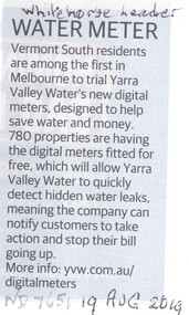
Article, Water Meter, 2019
... Yarra Valley Water... to trial Yarra Valley Water's new digital meters. Designed to alert... Water Yarra Valley Water Vermont South residents are among ...Vermont South residents are among the first in Melbourne to trial Yarra Valley Water's new digital meters.Vermont South residents are among the first in Melbourne to trial Yarra Valley Water's new digital meters. Designed to alert customers of water leaks.Vermont South residents are among the first in Melbourne to trial Yarra Valley Water's new digital meters. vermont south, water, yarra valley water -
 Whitehorse Historical Society Inc.
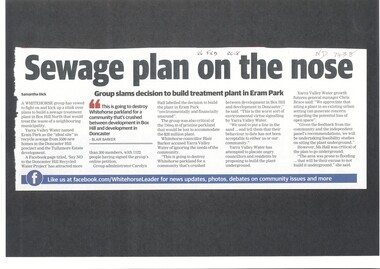
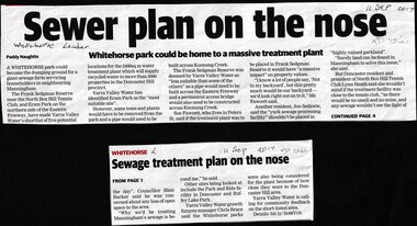
Article, Sewage Plan, 2018
... yarra valley water...Yarra Valley Water named Eram Park as the 'ideal site... Mitcham melbourne Article Article Sewage Plan Yarra Valley Water ...Yarra Valley Water named Eram Park as the 'ideal site' to recycle sewage from 5500 new homes in the Doncaster Hill precinct and Tullamore Estate development, but local residents are totally opposed it.sewerage and sanitation, yarra valley water, city of whitehorse, eram park -
 Vision Australia
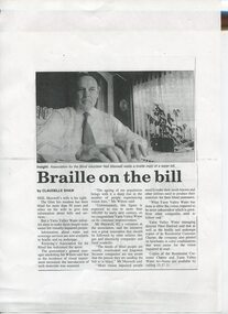
Article - Text, Braille on the bill by Claudelle Shaw
... Yarra Valley Water... Valley Water to provide Braille water bills for residents who... and the need for Yarra Valley Water to provide Braille water bills ...Summary update of Centenary AppealNewspaper article about Neil Maxwell and the need for Yarra Valley Water to provide Braille water bills for residents who are vision impaired.1 article photocopied from a newspapernon-fictionelizabeth maxwell, neil maxwell, yarra valley water, advocacy -
 Eltham District Historical Society Inc
Photograph, Liz Pidgeon, Heritage Excursion; Maroondah Aqueduct, 3 September 2016
... yarra valley water...Property related to Yarra Valley Water, Diamond Creek... Valley Water, Diamond Creek Newsletter No., 229, August 2016 ...Property related to Yarra Valley Water, Diamond Creek Newsletter No., 229, August 2016 Heritage Excursion - Maroondah Aqueduct Walk - Saturday 3rd September The Maroondah Aqueduct was once a major link in Melbourne’s water supply system. It was built between 1886 and 1891 to transfer water from the Watts River near Healesville to the Preston Reservoir. It was 66 km in length, made up of 41 km of open channel, 10 km of tunnel through hills and 15 km of pipeline across stream valleys known as inverted siphons. The section of the aqueduct through the Eltham area has been abandoned since the 1980s but the open channel has largely been retained. A recreational path follows the aqueduct reserve. For our excursion on 3rd September we intend to walk along the section of the aqueduct adjacent to Allendale Road. This is a section not visited on previous excursions and includes the transition from open channel to the inverted siphon across the Diamond Creek valley. Apart from the aqueduct itself the main feature of the walk is the extensive views across Eltham North and Diamond Creek. Along the way we will talk about the history of the aqueduct and the area. This easy walk is about 3 km return and will take 2 to 2.5 hours. It will start at 2pm at the junction of Allendale Road with Godber Road and Zig Zag Road North, officially Diamond Creek, but on the northern boundary of Eltham. (Melway ref.12 B10). Born Digitalmaroondah aqueduct, eltham north, activities, eltham district historical society, heritage excursion, yarra valley water, diamond creek -
 Eltham District Historical Society Inc
Photograph, Liz Pidgeon, Heritage Excursion; Maroondah Aqueduct, 3 September 2016
... yarra valley water...Sign for Yarra Valley Water at Diamond Creek property... Aqueduct, 3 September 2016 Born Digital Sign for Yarra Valley Water ...Sign for Yarra Valley Water at Diamond Creek property Newsletter No., 229, August 2016 Heritage Excursion - Maroondah Aqueduct Walk - Saturday 3rd September The Maroondah Aqueduct was once a major link in Melbourne’s water supply system. It was built between 1886 and 1891 to transfer water from the Watts River near Healesville to the Preston Reservoir. It was 66 km in length, made up of 41 km of open channel, 10 km of tunnel through hills and 15 km of pipeline across stream valleys known as inverted siphons. The section of the aqueduct through the Eltham area has been abandoned since the 1980s but the open channel has largely been retained. A recreational path follows the aqueduct reserve. For our excursion on 3rd September we intend to walk along the section of the aqueduct adjacent to Allendale Road. This is a section not visited on previous excursions and includes the transition from open channel to the inverted siphon across the Diamond Creek valley. Apart from the aqueduct itself the main feature of the walk is the extensive views across Eltham North and Diamond Creek. Along the way we will talk about the history of the aqueduct and the area. This easy walk is about 3 km return and will take 2 to 2.5 hours. It will start at 2pm at the junction of Allendale Road with Godber Road and Zig Zag Road North, officially Diamond Creek, but on the northern boundary of Eltham. (Melway ref.12 B10). Born Digitalmaroondah aqueduct, eltham north, activities, eltham district historical society, heritage excursion, diamond creek, yarra valley water, sign -
 Whittlesea Historical Society Inc.
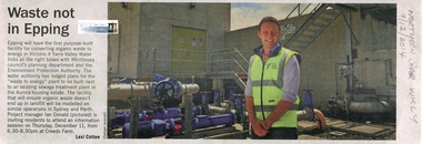
Newspaper - Article, Northern Star Weekly, Waste not in Epping, 9 Dec 2014
... yarra valley water.... Project manager Ian Donald pictured. ian donald yarra valley water ...Information session on a "waste to energy" plant to be built in the Aurora housing estate Epping. Project manager Ian Donald pictured.Newsprint, text with colour photograph.ian donald, yarra valley water, epping, organic waste plant epping -
 Whitehorse Historical Society Inc.
Article, Sewer Treatment Plant, 11/09/2017 12:00:00 AM
... Yarra Valley Water... householders in Manningham. Frank Sedgman Reserve Yarra Valley Water ...Frank Sedgman Reserve could become a giant sewage farm servicing householders in Manningham.Frank Sedgman Reserve could become a giant sewage farm servicing householders in Manningham.Frank Sedgman Reserve could become a giant sewage farm servicing householders in Manningham.frank sedgman reserve, yarra valley water, sewerage and sanitation -
 Eltham District Historical Society Inc
Document, Notice of Decision to Grant a Permit; Ref: E94/306 - Subdivision of 30-34 Diosma Road; 16 November 1994, 16/11/1994
... objection and the land was donated by Yarra Valley Water for use... was donated by Yarra Valley Water for use as a community reserve ...This permit was eventually overturned following community objection and the land was donated by Yarra Valley Water for use as a community reserve.The Stokes Orchard Estate collection is typical of housing developments of the late 1970s and 1980s. It was one of the earliest estates in Eltham following the nearby Woodridge Estate development.A4 document consisting of ten pagesAs notedstokes place, eltham, stokes orchard, stokes orchard estate, streets, houses, peter and carla vermey, diosma road, letter of objection, melbourne metropolitan board of works, planning application, reservoir, shire of eltham -
 Eltham District Historical Society Inc
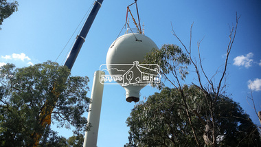
Photograph, Demolition of water tower at 51 Cassells Road, Research, 6 April 2017, 6/4/2017
... , and the tower was removed in March 2017." Source: Yarra Valley Water...: Yarra Valley Water Eltham Water Project online cassells road ..."The water storage tank (the ‘golf ball’ tower) was located in Cassells Road, and for many years it played an important role in supplying the Research and Eltham communities with drinking water. However, due to prior upgrades of water supply infrastructure in the area, these communities are receiving their water supply in a more reliable way. The storage tank was no longer operating and as it no longer served a purpose, the time had come for it to be removed. Decommissioning works occurred between November 2016 and January 2017, and the tower was removed in March 2017." Source: Yarra Valley Water Eltham Water Project onlineDigital files only (17 jpg and one two second MP4 files)cassells road, demolition, research (vic.), water tower -
 Federation University Art Collection
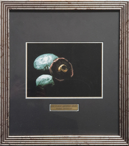
Photograph, Steinfort, Jessie, 'Mushrooms' by Jessie Steinfort, 1998
... Food & Wine Festival, AAMI, Yarra Valley Water, and Arts Centre..., AAMI, Yarra Valley Water, and Arts Centre Melbourne. From 2008 ...Jessie STEINFORT Steinfort was Studied Graphic Design at the University of Ballarat (later Federation University) After 12 years of working in design studios and advertising agencies, Steinfort is now a Senior Designer at Ogilvy Melbourne. And previously, he has been responsible for work on BMW & Mini, Carlton Football club, Melbourne Convention and Exhibition Centre, Melbourne Food & Wine Festival, AAMI, Yarra Valley Water, and Arts Centre Melbourne. From 2008 to 2011 Steinfort was lead designer and front-end web developer at clickDM (now HARDWIRE). Where he worked with such clients as HOSTPLUS, GSK, UniSuper and Swann Insurance. From 2000 to 2008 Steinfort was a designer at Mediation Communications working on print and interactive projects for; City of Melbourne, City of Greater Geelong, City of Port Phillip, Mentor Education, and ACMA. This item is part of the Federation University Art Collection. The Art Collection features over 2000 works and was listed as a 'Ballarat Treasure' in 2007. Framed photograph of three mushrooms in a black background. This work was won the 1998 Student Acquisition Award. If you can provide information on this artist or artwork please use the email link below. photography, foto, mushrooms, food, close up, macro, colour, photo, jessie steinfort, alumni, available -
 Ringwood and District Historical Society
Document - Folder, Commercial and Retail Property Sales Information, Civic Place and Melbourne Street, Ringwood - 1998
... , 22 & 24 Melbourne Street Mall. - Yarra Valley Water..., 22 & 24 Melbourne Street Mall. - Yarra Valley Water ...45 photocopied pages including - Plan of Subdivision No.LP80718, Parish of Ringwood, Victoria, Crown Portion 12(Part) and part of a former government road Ref Vol 8668 Fol 745. - Vendors Statement, Planning Certificate and Heritage Council (Victoria) Certificate issued for 20 Melbourne Street, Ringwood. - Maroondah City Council Land Information Certificate for 149 149A and 149B Maroondah Highway; number 8 Civic Mall; and numbers 16, 20, 22 & 24 Melbourne Street Mall. - Yarra Valley Water statements relating to encumbrances for Shop 11, 149 Maroondah Highway; Shop 10, 149A Maroondah Highway; Shop 9, 149B Maroondah Highway; numer 8 Civic Place; Unit 3, 20 Melbourne Street; Office 4, 20 Melbourne Street; Shop 7, 22 Melbourne Street; and Shop 8, 24 Melbourne Street. - Land Tax Certificate pertaining to Commonwealth Bank, Civic Place, Ringwood. - Certificate of Title Vol 8892 Fol 906, Lot One on Plan of Subdivision No. 80718, Parish of Ringwood - Hanover Developments P/L - 29th June, 1971. -
 Greensborough Historical Society
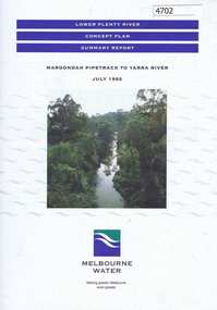
Pamphlet, Lower Plenty River concept plan, summary report: Maroondah Pipetrack to Yarra River, 1992_07
This draft concept plan covers the lower Plenty River from the Maroondah Pipe track in Greensborough to where the Plenty meets the Yarra. Melbourne Water was the lead agency, assisted by the Shires of Eltham and Diamond Valley, City of Heidelberg, the EPA and Department of Planning and Housing.Coloured pamphlet, photograph and plans 12 pages. 2 copies.plenty river, maroondah aqueduct, melbourne water -
 Federation University Historical Collection
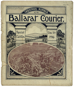
Magazine - Photograph - Black and White, Berry, Anderson & Co, Ballarat Courier Special Christmas Edition, 1916
A magazine supplement of the Ballarat Courier containing articles, images and advertisement. Images include: St Patrick's Day March, Eight Hour Day procession Advertisements include: Morris undertaker, Olivers, Miller, Hanrahan's Hotelst patrick's day, ballarat townscape, st patrick's day parade, ballarat st patrick's day parade, ballarat courier, hanrahan, morris, labour day, 8 hour day, eight hours day procession, st patrick's day procession, mrs captain ellis, picture palace, grenville college, berry united company ullina, lewis s. smith architect, bolster brothers, buninyong butter factory, aquatic carnival, george e. deeble machinery, cape nelson portland, jelbarts, jelbart's telescope, lin hillman, presbyterian church snake valley, miss a.m. abrams, berry anderson and co, j.a. reynolds, maypole, w.f. coltman, ballarat boot palace, ben nevis elmhurst, jonathan reeve, victorian producers co-operative, r.u. nicholls, f.w. barnes and son, ballarat steam laundryballarat water reserves, yarra river warburton, erskine river lorne, john bray, eden studios, lake wendouree -
 Marysville & District Historical Society
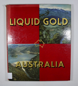
Book, Clive Turnbull, Liquid Gold-Australia, 1960
A book that outlines the importance of irrigation and water usage used in various industries in the Goulburn Valley and North Eastern Victoria.Front cover has two photographs. On of a treed valley leading up to snow covered mountains and on of a water reservoir surrounded by bushland.non-fictionA book that outlines the importance of irrigation and water usage used in various industries in the Goulburn Valley and North Eastern Victoria.water, industry, irrigation, australia -
Marysville & District Historical Society
Booklet (Item) - Information booklet, Artworkz Tourism, The Big Culvert, Unknown
An information booklet that was produced as a guide to The Big Culvert.An information booklet that was produced as a guide to The Big Culvert. The Big Culvert is a historic granite and bluestone arch along the Yarra Track, a major route to Melbourne through the 1800s. Built in 1870 and a major piece of infrastructure for its time, the heritage listed culvert allowed water to flow under often-flooded the road. The Yarra Track is the former name of the gold fields road from Healesville to the Woods Point and Jordan Goldfields, in Victoria, Australia. A direct route via the Yarra River and the Great Divide was discovered by Rieck in September 1862 and became known as the Yarra Track. Early in 1863, the Victorian Government decided to construct a 193-kilometre (120 mile) road along the route. Its original width varied between 4 and 6 metres (12 and 20 feet), and was designed to accommodate horse-drawn vehicles. The Track involved the climbing of the Black Spur, descent into the Acheron Valley, and then through Marysville to the Cumberland where it followed the existing route.the big culvert, yarra track, victoria, healesville, wood's point goldfields, jordan goldfields, black spur, acheron valley, cumberland valley -
Marysville & District Historical Society
Flyer (Item) - Information flyer, Artworkz Tourism, The Big Culvert, 26-03-2016
An information flyer that was produced as a guide to The Big Culvert.An information flyer that was produced as a guide to The Big Culvert. The Big Culvert is a historic granite and bluestone arch along the Yarra Track, a major route to Melbourne through the 1800s. Built in 1870 and a major piece of infrastructure for its time, the heritage listed culvert allowed water to flow under often-flooded the road. The Yarra Track is the former name of the gold fields road from Healesville to the Woods Point and Jordan Goldfields, in Victoria, Australia. A direct route via the Yarra River and the Great Divide was discovered by Rieck in September 1862 and became known as the Yarra Track. Early in 1863, the Victorian Government decided to construct a 193-kilometre (120 mile) road along the route. Its original width varied between 4 and 6 metres (12 and 20 feet), and was designed to accommodate horse-drawn vehicles. The Track involved the climbing of the Black Spur, descent into the Acheron Valley, and then through Marysville to the Cumberland where it followed the existing route.the big culvert, yarra track, victoria, healesville, wood's point goldfields, jordan goldfields, black spur, acheron valley, cumberland valley -
 Marysville & District Historical Society
Postcard (item) - Black and white postcard, Valentine Publishing Co. Pty. Ltd, Steavenson Falls, Marysville V.15, 1923-1963
A black and white photograph of Stevenson (Steavenson) Falls in Marysville in Victoria.A black and white photograph of Stevenson (Steavenson) Falls in Marysville in Victoria. The Steavenson Falls is named after the Victorian Assistant Commissioner of Roads and Bridges, John Steavenson who arrived in Victoria in the early 1860s. This postcard was published by the Valentine Publishing Co. Pty. Ltd. as a souvenir of Marysville.VALENTINE'S/ POST CARD/ A GENUINE PHOTOGRAPH Water falls/ see twice/ at night/ once in the/ day/ height 271 ft. MARY-LYN GUEST HOUSE/ BONES 7 FISKE, Propsteavenson falls, marysville, victoria, waterfalls, postcard, valentine publishing co, souvenir, john steavenson -
 Marysville & District Historical Society
Photograph (Item) - Colour photograph, 20-09-2008
A colour photograph of the entrance to The Big Culvert.A colour photograph of the entrance to The Big Culvert. The Big Culvert is a historic granite and bluestone arch along the Yarra Track, a major route to Melbourne through the 1800s. Built in 1870 and a major piece of infrastructure for its time, the heritage listed culvert allowed water to flow under often-flooded the road. The Yarra Track is the former name of the gold fields road from Healesville to the Woods Point and Jordan Goldfields, in Victoria, Australia. A direct route via the Yarra River and the Great Divide was discovered by Rieck in September 1862 and became known as the Yarra Track. Early in 1863, the Victorian Government decided to construct a 193-kilometre (120 mile) road along the route. Its original width varied between 4 and 6 metres (12 and 20 feet), and was designed to accommodate horse-drawn vehicles. The Track involved the climbing of the Black Spur, descent into the Acheron Valley, and then through Marysville to the Cumberland where it followed the existing route.the big culvert, yarra track, victoria, healesville, wood's point goldfields, jordan goldfields, black spur, acheron valley, cumberland valley -
 Marysville & District Historical Society
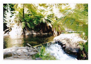
Photograph (item) - Colour photograph, Pre 2009
A colour photograph of the pool at the base of the Steavenson Falls in Marysville in Victoria. A colour photograph of the pool at the base of the Steavenson Falls in Marysville in Victoria. The Steavenson Falls is named after the Victorian Assistant Commissioner of Roads and Bridges, John Steavenson who arrived in Victoria in the early 1860s.steavenson falls, waterfalls, marysville, victoria, john steavenson -
 Marysville & District Historical Society
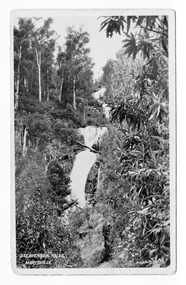
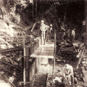
Photograph (item) - Black and white photograph, Unknown
A black and white photograph which shows a group of men constructing the form work for the dam at the base of Steavenson Falls.A black and white photograph shows a group of men constructing the form work for the dam at the base of Steavenson Falls. Steavenson Falls provides Marysville with the town's drinking water which is considered to be the second-best drinking water in the world. The Steavenson Falls are named after the Victorian Assistant Commissioner of Roads and Bridges, John Steavenson who arrived in Victoria in the early 1860s.steavenson falls, marysville, victoria, waterfalls, john steavenson, 2009 black saturday bushfires -
 Marysville & District Historical Society
Photograph (Item) - Colour photograph, 2006
A colour photograph of the Crossways Hotel in Marysville in Victoria.A colour photograph of the Crossways Hotel in Marysville in Victoria. The Crossways Hotel is circa 1920 and one of the oldest buildings still standing in Marysville. The Crossways Hotel survived the 2009 Black Saturday bushfires, through the efforts of the owner using buckets of water from the nearby Steavenson River.crossways hotel, marysville, victoria, photograph, 2009 black saturday bushfires -
 Marysville & District Historical Society
Photograph (Item) - Colour photograph, Travel Victoria, Unknown
A colour photograph of Murchison Street in Marysville in Victoria.A colour photograph of Murchison Street in Marysville in Victoria. The photograph shows The Crossways Hotel. The Crossways Hotel is circa 1920 and one of the oldest buildings still standing in Marysville. The Crossways Hotel survived the 2009 Black Saturday bushfires, through the efforts of the owner using buckets of water from the nearby Steavenson River.murchison street, marysville, victoria, the crossways hotel, photograph, 2009 black saturday bushfires -
 Marysville & District Historical Society
Photograph (Item) - Black and white photograph, 1953
A black and white photograph of the water wheel which provided power to the Barton Bros Store in Marysville in Victoria.A black and white photograph of the water wheel which provided power to the Barton Bros Store in Marysville in Victoria. This water wheel was located on the Steavenson River in Marysville. Barton's Store was established by Thomas John Barton in 1864. Thomas John Barton was born in 1836 in Gloucestershire and after his father died in 1850 arrived in Melbourne in 1852 along with his mother, adult sisters, younger brothers, his uncle, his uncle's wife Suzanna and their family. Thomas tried gold mining at Woods Point but found it too difficult. He then partnered with Ewen Hugh Cameron to provide the miners with meat. In 1864 they purchased a plot of land in Marysville and set up a butchers/abattoirs and from there began their business of taking supplies to the miners at the nearby Woods Point and Jamieson goldfields. In 1865 the business was firmly established and Thomas married Selina Croker at Heidelberg and brought her back to Marysville. Their first home was 'The Chestnuts', which included the store, and was situated on the town side next to the Steavenson River. Sadly, in 1876 Selina died of complications after giving birth to their sixth child. Thomas was in need of a nanny to care for his six children, including the newborn baby, and so he employed Emily Ada Sparke, who is the eldest daughter of the local school teacher. Thomas and Emily subsequently marry in 1878 and they go on to have a further 10 children over the next several years. Thomas assisted in the establishment of the first school in Marysville in 1870 and remained a very active member of the community including as a Councillor for the Shire of Healesville, Shire President and he was also appointed as a Justice of the Peace. Thomas died in Carlton in 1911. After their father's death, his sons Fred and Frank took over the family business, which was then known as Barton Bros Store which continued to operate until sometime in the 1970's.WATER WHEEL./ MARYSVILLE '53marysville, victoria, barton's store, thomas john barton, ewen hugh cameron, woods point, jamieson, gold mining, goldfields, selina croker, the chestnuts, emily ada sparke, shire of healesville, fred barton, frank barton, barton bros store, francis adam barton, frederick john barton, water wheel, steavenson river, photograph -
 Marysville & District Historical Society
Photograph (Item) - Black and white photograph, Sun-Herald, 1953
A digital copy of a black and white photograph of the water wheel that used to provide power to the Barton Bros Store in Marysville in Victoria.A digital copy of a black and white photograph of the water wheel that used to provide power to the Barton Bros Store in Marysville in Victoria. This water wheel was located on the Steavenson River in Marysville. Barton's Store was established by Thomas John Barton in 1864. Thomas John Barton was born in 1836 in Gloucestershire and after his father died in 1850 arrived in Melbourne in 1852 along with his mother, adult sisters, younger brothers, his uncle, his uncle's wife Suzanna and their family. Thomas tried gold mining at Woods Point but found it too difficult. He then partnered with Ewen Hugh Cameron to provide the miners with meat. In 1864 they purchased a plot of land in Marysville and set up a butchers/abattoirs and from there began their business of taking supplies to the miners at the nearby Woods Point and Jamieson goldfields. In 1865 the business was firmly established and Thomas married Selina Croker at Heidelberg and brought her back to Marysville. Their first home was 'The Chestnuts', which included the store, and was situated on the town side next to the Steavenson River. Sadly, in 1876 Selina died of complications after giving birth to their sixth child. Thomas was in need of a nanny to care for his six children, including the newborn baby, and so he employed Emily Ada Sparke, who is the eldest daughter of the local school teacher. Thomas and Emily subsequently marry in 1878 and they go on to have a further 10 children over the next several years. Thomas assisted in the establishment of the first school in Marysville in 1870 and remained a very active member of the community including as a Councillor for the Shire of Healesville, Shire President and he was also appointed as a Justice of the Peace. Thomas died in Carlton in 1911. After their father's death, his sons Fred and Frank took over the family business, which was then known as Barton Bros Store which continued to operate until sometime in the 1970's.marysville, victoria, barton's store, thomas john barton, ewen hugh cameron, woods point, jamieson, gold mining, goldfields, selina croker, the chestnuts, emily ada sparke, shire of healesville, fred barton, frank barton, barton bros store, francis adam barton, frederick john barton, water wheel, steavenson river, photograph -
 Marysville & District Historical Society
Postcard (Item) - Colour tinted postcard, Murray Views, Murray Views No. 51. The Water Wheel, Marysville, Vic, 1950
A digital copy of a colour tinted postcard of the water wheel that powered the Barton's Store in Marysville in Victoria.A digital copy of a colour tinted postcard of the water wheel that powered the Barton's Store in Marysville in Victoria. This water wheel was located on the Steavenson River in Marysville. Barton's Store was established by Thomas John Barton in 1864. Thomas John Barton was born in 1836 in Gloucestershire and after his father died in 1850 arrived in Melbourne in 1852 along with his mother, adult sisters, younger brothers, his uncle, his uncle's wife Suzanna and their family. Thomas tried gold mining at Woods Point but found it too difficult. He then partnered with Ewen Hugh Cameron to provide the miners with meat. In 1864 they purchased a plot of land in Marysville and set up a butchers/abattoirs and from there began their business of taking supplies to the miners at the nearby Woods Point and Jamieson goldfields. In 1865 the business was firmly established and Thomas married Selina Croker at Heidelberg and brought her back to Marysville. Their first home was 'The Chestnuts', which included the store, and was situated on the town side next to the Steavenson River. Sadly, in 1876 Selina died of complications after giving birth to their sixth child. Thomas was in need of a nanny to care for his six children, including the newborn baby, and so he employed Emily Ada Sparke, who is the eldest daughter of the local school teacher. Thomas and Emily subsequently marry in 1878 and they go on to have a further 10 children over the next several years. Thomas assisted in the establishment of the first school in Marysville in 1870 and remained a very active member of the community including as a Councillor for the Shire of Healesville, Shire President and he was also appointed as a Justice of the Peace. Thomas died in Carlton in 1911. After their father's death, his sons Fred and Frank took over the family business, which was then known as Barton Bros Store which continued to operate until sometime in the 1970's. This postcard was produced by Murray Views in 1950 as a souvenir of Marysville.marysville, victoria, barton's store, thomas john barton, ewen hugh cameron, woods point, jamieson, gold mining, goldfields, selina croker, the chestnuts, emily ada sparke, shire of healesville, fred barton, frank barton, barton bros store, francis adam barton, frederick john barton, water wheel, steavenson river, murray views, murray views no. 51, postcard, souvenir -
 Marysville & District Historical Society
Photograph (Item) - Black and white photograph, Unknown
A digital copy of a black and white photograph of the water wheel that used to provide power to the Barton Bros Store in Marysville in Victoria.A digital copy of a black and white photograph of the water wheel that used to provide power to the Barton Bros Store in Marysville in Victoria. This water wheel was located on the Steavenson River in Marysville. Barton's Store was established by Thomas John Barton in 1864. Thomas John Barton was born in 1836 in Gloucestershire and after his father died in 1850 arrived in Melbourne in 1852 along with his mother, adult sisters, younger brothers, his uncle, his uncle's wife Suzanna and their family. Thomas tried gold mining at Woods Point but found it too difficult. He then partnered with Ewen Hugh Cameron to provide the miners with meat. In 1864 they purchased a plot of land in Marysville and set up a butchers/abattoirs and from there began their business of taking supplies to the miners at the nearby Woods Point and Jamieson goldfields. In 1865 the business was firmly established and Thomas married Selina Croker at Heidelberg and brought her back to Marysville. Their first home was 'The Chestnuts', which included the store, and was situated on the town side next to the Steavenson River. Sadly, in 1876 Selina died of complications after giving birth to their sixth child. Thomas was in need of a nanny to care for his six children, including the newborn baby, and so he employed Emily Ada Sparke, who is the eldest daughter of the local school teacher. Thomas and Emily subsequently marry in 1878 and they go on to have a further 10 children over the next several years. Thomas assisted in the establishment of the first school in Marysville in 1870 and remained a very active member of the community including as a Councillor for the Shire of Healesville, Shire President and he was also appointed as a Justice of the Peace. Thomas died in Carlton in 1911. After their father's death, his sons Fred and Frank took over the family business, which was then known as Barton Bros Store which continued to operate until sometime in the 1970's.marysville, victoria, barton's store, thomas john barton, ewen hugh cameron, woods point, jamieson, gold mining, goldfields, selina croker, the chestnuts, emily ada sparke, shire of healesville, fred barton, frank barton, barton bros store, francis adam barton, frederick john barton, water wheel, steavenson river, photograph -
Upper Yarra Museum
Food Safe, Untitled
http://museumvictoria.com.au/discoverycentre/infosheets/the-coolgardie-safe/ http://en.wikipedia.org/wiki/Coolgardie_safe The Coolgardie Safe is a low-tech refrigeration unit which uses the heat transfer which occurs during evaporation of water. It was named after the place where it was invented — the small mining town of Coolgardie, Western Australia, near Kalgoorlie-Boulder. http://www.biggles.com.au/ The Coolgardie Safe was simply a wire framed box with wheat sack strips hanging down the sides, which were kept wet by the process of osmosis from a dish or small tank of water. The food inside the Safe was kept cool due to the principle that evaporation takes away heat; the wet hessian strips experience evaporation from the wind and the sun and thus you have a refrigerator. http://www.whitehat.com.au/australia/Inventions/InventionsA.html Coolgardie Safe made from galvanised iron with hessian drapped over 4 sides, rectangular on 4 legs. 2 trays inside, 3rd tray inserted in top as cover, metal meshing on callapsable sides and door. Stands in tray. The tray assists with pest control as it was filled with water.kitchen galvanised iron coolgardie safe hessian food preservation pest control water -
 Upper Yarra Museum
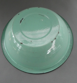
Hand basin
These Enamal wash basins could be found in most homes, shacks and tents, up untill the use of internal plumbing and sinks.Green enamel basinenamal basin wash water soap personal hygene -
 Upper Yarra Museum
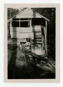
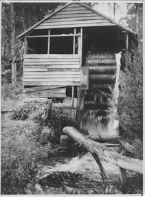
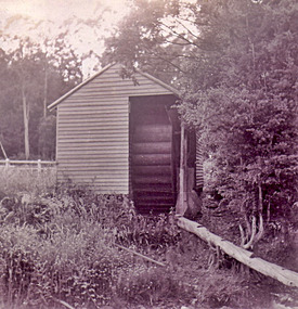
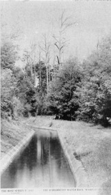
Negative Photographic Reproduction, O'Shannessy Water race